 Dharug Country across the City is a website based on the current post-doctoral research project of Dr Jo Anne Rey, a Dharug community member, in collaboration with Dharug community and other allies. The research project, ‘Weaving Country across the City: Activating Dharug Ngurra’ is funded through the 2020 Macquarie University Fellowship for Indigenous Research (MUFIR).
The site was developed to inform people about Dharug activism and agency, continuing caring for Country/Ngurra even when Country is a city. It seeks to inform the public of the revitalisation of cultural practices, perspectives, and ways of knowing, being and doing through the storying of past-present-futures.
Following the research project, the site links to the three project sites:
- Shaw’s Creek Aboriginal Place, located at the foot of the Blue Mountains in far western Sydney
- Blacktown Native Institution site, located at Oakhurst, in central western Sydney
- Brown’s Waterhole, Lane Cove National Park, northern Sydney
More details about each of these sites is available within their specifically linked portals.
ABOUT DHARUG NGURRA
Dharug Ngurra (Country) covers the majority of the Sydney basin, from the ocean to the western edge of the Blue Mountains. I like to teach about Ngurra by getting students to imagine they are a hawk, flying around the boundaries. It goes like this:
Imagine you are a Hawk, and you take off and fly north along the coast from what today is Sydney airport, on the northern edge of Botany Bay. You fly over the mouth of Sydney Harbour, keeping the ocean under your right wing, and the landscape under your left wing. You fly all the way up the coast, with the northern beaches underneath you, until you get to what today is called Broken Bay, or the mouth of the Hawkesbury River. We call this river system Deerubbin, and it includes both the Hawkesbury and Nepean.
At this point we turn west and fly along the Deerubbin (Hawkesbury) until we reach the Colo River. We follow the Colo and then head south-west until we get to the western edge of the ridge line that crosses the Blue Mountains and is known as the Great Western Highway today. When we get to the town of Medlow Bath, we turn east, and follow the ridgeline until we get back to the Deerubbin (Nepean). We then head south, along the river until we get to around the location of the town of Camden. At this point we head east again, until we reach the George’s River. Keeping the river below us, we follow the river along its northern bank until we get back to Botany Bay. At this point, everything lying under our left-wing is the landscape of Dharug Ngurra. All the presences, places, and traditional custodians and Ancestors from this Ngurra are Dharug. Ngurra also includes the waterways, the ocean, the sky, the stars, all the physical and metaphysical belonging, caring and connecting that together are the agency of Dharug Ngurra.
There are various versions told and in written form that debate and dispute the boundaries of Dharug Ngurra. However, these water boundaries are spoken of consistently in stories told by Dharug peoples.
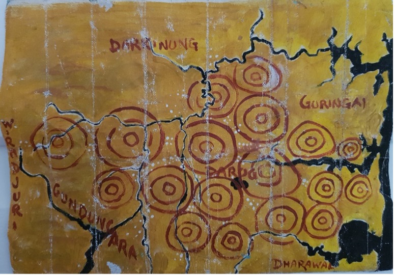
Here is a representation of Dharug Ngurra by Uncle Chris Tobin with some of the centres of caring for Country that existed long before and at the time of British arrival in 1788.
In contrast below is another representation of Dharug Ngurra drawn by Jo Rey and indicates only one version of spellings.
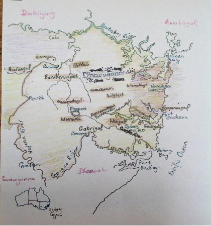
Image: J. Rey: Dharug Nura Map of approximate boundaries. Extract from Doctoral Thesis Rey, J. (2019) Country Tracking Voices: Dharug women’s perspectives on presences, places, and practices.
The Dharug Nura Map (above right) doesn’t include all clan areas. What we can say is that ‘maps’ vary according to diverse knowledges and perspectives. However, the family groups named represent those that were discussed by interview participants in the doctoral thesis, Country Tracking Voices: Dharug women’s perspectives on presences, places and practices.
Family group names are marked in black.
Suffix -gal indicates ‘people/man of’. Modern place names, e.g. Botany Bay, are marked in blue.
Some Dharug Country Group Names
Aurung, Bidjee, Burramatta, Buruberong, Gammerai, Cattai, Durramatta, Gabri, Gadi, Gari, Gaimari, Kurrajong, Mulgoa, Wallumatta, Wanne, Warmuli, Wianamatta.
Our Neighbours
On the map our neighbours’ names are marked in red.
Awaba, Dharawal, Darkingjung, Gundungurra, Wiradjeri (west of the Blue Mountains – not shown on the map).